
Just finished hitting my second trail of this year: Mount Wilson trail! Conquered it this past Saturday with David and another friend. Can I say, I’m so glad I went with the right company. There were so many laughs and cries on this weekend’s adventure. Hiking with the right people is always the best thing (although, I’m all for solo adventures/hiking, but always make sure to play it safe and notifying people of where you are going).
The original route was to meet and take Chantry Flats trail to Sturtevant Falls which would have lead past Mount Zion and to Mount Wilson and loops back down to the parking lot. Total would’ve bee somewhere between 13-14 miles from what I read online, but again, I was going to track the hike on my own. For the original hiking route, an Adventure Pass would’ve been needed, which I bought and left on my dash. Unfortunately, it was not needed. The route to Chantry Flats ended up being closed and will be closed until mid 2022 due to wild fire damage that was done back at the end of 2020. I did do my research and did see that the trail was ‘closed’ but I was hoping the site was wrong and because it’s been over a year, I really hoped it would’ve been open by now. It’s extra unfortunate that the trail was closed even earlier back around February/March 2020 when the pandemic hit and everyone ended up going outside to hike. As retaliation, the county decided to close hiking trails, then the Bobcat Fire happened so the closure ended up being even longer. Will it be back open? Unsure at the moment (they say April of 2022, but from my past experiences, county tends to postpone opening trails if they can).
I was a little disappointed since I wanted to conquer this trail because I had done it once before unintentionally via getting lost. I was ill prepared with no food and not enough water, the sun was also going down so it was getting dark. I remember panicking so terribly that I ended up crying, but somehow we managed to finish and found our way out. We ended up routing to Plan B: Mount Wilson Trail just a street over.

Parking is within a residential neighborhood and it’s free. We got there at 5:30AM and had plenty of parking (we parked right at the entrance of the trail). Please remember to be courteous, especially if you’re there early. There were a few porta-potties when we started, but there were large signs that mentioned that it wasn’t for public use (assuming maybe it’s just for workers?). There were also restrooms at the observatory, but it ended up being locked. So please use the restroom before going and pace yourself on your water consumption. It’s a long way up and down before you see a restroom.
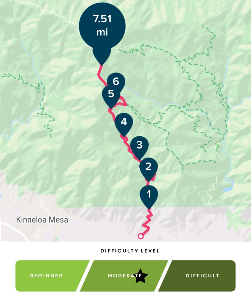
I was really hoping to finish the hike within 5 hours, but I wasn’t aware just how strenuous the hike was. Here was the listed details on the trail according to online sites and trail board:
HIKING DETAILS
Roundtrip: 14 miles
Difficulty: Difficult
Time: 6 Hours
Elevation Gain: 5,640
Pets: Allowed, but must be leashed
Permit: Not needed
We packed 3 liters of water each and wore a light jacket since it was a cloudy day (58°F/14.4°C in the morning, 66°F/19°C at the summit), but we also know that once you’re above the clouds, the sun tends to get pretty warm (I’ve ridden ACH area enough to know that this is true, where the city is gloomy and cloudy but once up in the mountains and past the clouds, it’s straight blue skies and full sun). For sustenance, we packed some Aussie Bites (these little things are so delish, packed with oatmeal, cranberries, and other healthy grains to give you energy), dried fruit strips for sugar and a spinach wrap and tuna salad for breakfast. Make sure to also have a HAM radio with you since most of the trail there’s no cell service, always want to make sure you have a line of communication if one were to get lost.
The trail was shady since it was cloudy and it was also early enough that the sun wasn’t really out yet so temperature was relatively cool. The overall hike wasn’t difficult in terms of physical climbing and stuff, but the sheer distance and the constant incline of the mountain was low-key brutal. The hike up was strenuous but I found it much easier than coming down because my body was at 100% and I had my full energy. I felt mostly fine with a little bit of tiredness when we were 6.5 miles up. It gets pretty high up so I also warn those that are acrophobic like me to be careful where one steps, the trail at some points gets narrow. Once we reached the top (the observatory), we saw some beautiful views of clouds swimming along the mountains. The entire area was covered in a sea of fluffy whiteness, it was gorgeous. I think we lucked out that the clouds were low for that weekend because usually there’s nothing much to see besides a parking lot, some antennas and the (currently half burnt) mountains of Angeles Crest Highway. There’s also a little cafe called the Cosmic Cafe that’s located there, although it’s currently closed due to the pandemic. But it’s a great place to have your food break since they have shaded tables and trashcans available. When we arrived nobody was near the cafe area so we had the place to ourselves for breakfast/lunch. There’s also water pack refilling station as well.
It’s a great trail for training, we met a lot of other hikers that were using this trail as training for longer hikes in the future, but definitely not a lot to see for all the hard work put into getting there. It can be somewhat demoralizing, so if you’re the type to want to get something from this hike, this trail might not be it for you. I clocked the end of the hike at 4 hours and 22 minutes to ascent 7.5 miles.
It was the descent that started to take us out. Even with our stomachs full with breakfast, our bodies had already done 7.5 miles and were weary from the incline work. The sun was also out and about now and since we were above the clouds, the trail was now covered in sun. No more shade, so remember to bring sunblock! Mile by mile we could feel muscle fatigue setting in, our quads and hamstrings were tightening up, our knees were getting tired, and I can feel my glutes also starting to get really sore. The constant downward position was also rubbing my toes against my shoe that it started to get really painful. But we had to push onward, towards the 13th and 14th mile I could file a little bit of delirium setting in. I had to laugh at everything or else I would’ve just wanted to cry from the pain in my feet and how physically tired I was. Our pacing was faster though, we finished the descent at 3.5 hours so almost an hour faster than going up. Clocking out of my Fitbit, here’s the data recorded:
Roundtrip: 15 miles
Difficulty: Intermediate, scale of 1 (beginner) – 3 (advanced), 2.5
Elevation Gain: 5,074
Time Done: 8 hours

In my teenage years (80s), my high school friends and I used to hike those trails and some of the trails that we thought were “secret” in Chantry Flatts. Sometimes we would do it at night and it was scary. Love the photos, it brought back some memories.
That’s awesome! I’d be too afraid to hike at night ahahaha the darkest I’ve experienced was the early mornings before the sun is up.
We were young then. I know I could never do it now. 🙂